Great, Bryan!
Would you like to describe your final workflow and tools used here? I am trying to do similar for ebike tours. I recognized your arrow marker is a little bit ahead of where you are actually driving - just a tiny bit.
To make it more interesting audio vise you could opt for a better windproof mic or just add some audio infos afterwards when editing - just say something Also you could stop at some scenic points and have a look in the beautiful countryside
play the tour and use a screen capture app to save.
import FireFlyX video(s) to timeline
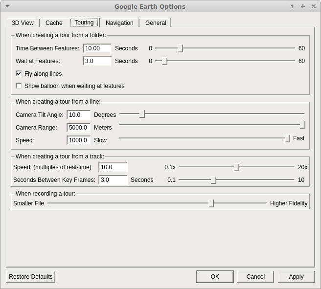
import screen capture to new video track. Note on the Google Earth Pro settings the tour playback is 10., so you need to change the properties of the clip to .1x
sync the videos - you are correct I’m about 1.5 secs out on the demo
used the “Clip Rectangle” and “Size and Position” filters on each video track to adjust where each clip displays.
export video. I always used default YouTube settings. My camera records in 2560x1440 so that’s what I export as. I have found with YouTube if you export at any thing less than 1440 YouTube will only re-encode your video using the avc codec and not vp9 (which is better), so you may need to get Shotcut to upscale your video even if you only intend to view at 1080p.
I’ve got a Zoom H1N for recording, just didn’t bother with this video as it was just a test of the GPS stuff.
Having watched your video, the thought came to me that rather than collecting the GPS data on your phone to recreate the mapping, that you could directly capture the map video on your phone.
My Samsung phone comes with a built in screen recorder app. (Other apps available).
Just start the map app and screen recorder and it should give a similar map recording.
That’s true, and while it may seem to be simpler by removing one step in the process, I think it would end up being a sub-optimal way to do it.
If you’re just collecting GPS data, your phone uses no mobile data, and generates a trivially small kml/gpx file. If you’re going to create the map in real time, you’re going to have probably a minimum of 3 sec GPS points, which means you need map data quite frequently, without offline maps you’re going to use a lot of mobile data. If you’re recording at a reasonable resolution, even at 24fps, that movie file will get big pretty fast, and drain your battery quick smart, even allowing for your phone having the processing power to actually do this.
I think it would be easier to generate the movie post GPS collection so you can tweak the camera angle, elevation, imagery etc to your liking (which of course you could do apriori for real time movie generation, but if you decided you wanted to tweak them after, you still need to re-generate the movie).
Thank you, Bryan, sounds interesting.
Instead of using GE pro did you ttry GE Studio?
Its already an animation tools with keyframing available, you even can set time of day and export the
tour as images to your computer or use the GE cloud service to do the complete rendering and recieve the mp4 file. it still has some bugs and is still in beta and you have to apply to use it.
But it is far better than GE pro regarding imagery and detail for 3d objects if you want to use it.
Also the keyframing of camera views, time of day etc. is great.
Not sure if you can easily import the GIS data as kml or gpx, but i think it will work.
Have to try that out. What GPS tracker would you recommend to use on a google pixel phone?
Freely available would be nice
GE Studio is really not that difficult if you are used to keyframing. Just move your camera, keyframe, go 5 sec. ahead, move your camera, keyframe and so on. You have to adjust the bezier curve handles to get the movement really smooth, that needs a bit of practice.
Ah, gps logger, i had a quick look into that, will give it a try
I’m new to working with geodata and happy to see any interesting cases like your app.
I read a guide on creating a location-aware app. It says that so-called assisted GPS is more accurate and drains less battery charge. What technology is used in your project? Is that pure GPS only? I’m asking your app geolocates pretty accurately.
I have a spare phone with no sim (not needed for GPS) which captures all the GPS points. I use 3 sec intervals, which for my purposes is plenty frequent enough. The app exports either a kml or gpx file which I load into Google Earth Pro. The I “play” the tour in GEP and use a screen capture app to capture the video. (Note you can set the speed of the video in GEP - I use x10).
I then import that video as a new video track into Shotcut, change the properties so speed is .1x to get it back to the same speed as my action cam video, then merge the two.
There’s probably more trick ways to do all this, but this workflow works fine for my use case.
 Also you could stop at some scenic points and have a look in the beautiful countryside